|
The Open Street Map project was inspired by Wikipedia and, like its encyclopedia, it is contributed to by a wide variety of volunteers all around the world. Unfortunately, like the encyclopedia, it not always entirely correct. However, it does mean, that it is free to users provided that they credit OpenStreetMap and its contributors. (This is actually done for you by ProOSM+.)
The main web site is at www.openstreetmap.org , where you can find out more about the project and obtain your .osm map files. Simply enter the name of the place you want to see and when you have set it to the scale you need, click on Export and your file will be downloaded. However, the Export only works on a PC. Use the !GetOSM application to obtain the files under RISC OS.
NB: If you zoom out too far you will end up with a blank screen when you try to export. There seems to be a limit for file size so you may be better with a few smaller maps if you need a bigger area. Also, if you zoom in too close you can actually lose data. This occurs when an area entirely covers the frame of reference or no vector points for a line type are within it.
The .osm file is basically a text file in what is known as xml format. It has been created for you as a result of selecting an area for export on the OpenStreetMap web site or by using !GetOSM. A huge amount of information is contained within it, much of which you may not be interested in. That is why selection filters have been provided in the full version to help weed out the information that is not required on the final map. Even selecting every possible thing to be displayed, the ProCAD+ version of the file is always significantly smaller than the original .osm file.
ProOSM+ reads the text of the OSM file and translates it into a ProCAD+ file which is a drawing of the map in vector form. It has its own library of over 100 different symbols which may appear on the map, but they are only called into the file if they are actually needed. ProCAD+ shares its symbols so only one copy of each symbol will be included. For experienced users of the full version it is even possible to substitute or add your own versions of the symbols.
The resultant file may then be edited and cleaned up in ProCAD+ before being printed or exported in Draw or PDF file format.
The OSM file can be large so the program can require large amounts of memory and in consequence, uses a large wimpslot. It is suitable for RISC OS 4 and higher.
This simple menu has only four options. The first opens the usual info. box which contains your serial number and the number and date of the version. These things should be mentioned when requesting support or an upgrade. The second option opens this Help file. The third option opens the main dialogue box or brings it to the front if it is already open and the fourth option is the usual Quit to exit the program and free up the memory it used.
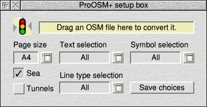
The main dialogue box is a relatively simple affair with only eight active elements to it. The top icon ifsfor displaying messages or instructions. The left-hand menu is for selecting the page size of the drawing to create, from A4 up to A0 (landscape). The next three menus are for choosing what text, symbols and line types you want to appear on your final drawing. If all possible items are ticked, 'All' is shown and 'None' for none. Anything else is indicated by 'Selection'. Once you have chosen your requirement using the menus, simply drag the OSM file onto the box and a ProCAD+ file will be created from it. The file may also be created by dragging he OSM file to the iconbar icon.
The bottom four options of the Text selection menu are different from those above them. Clicking on 'All' does not affect them. The group of three that deal with language and characters are described below. The last option, 'Above symols', causes the text to be placed above a symbol where the two would otherwise be coincident.
The 'Sea' button is usually on. This enables ProOSM+ to fill in any sea areas with pale blue. Turning this switch off reduces the coastline to a pale blue line instead. Some very complex coastlines ProOSM+ may not be able to process, so it will advise you to turn this switch off in this case.
Normally, things in tunnels are not shown but if they are required to be shown, just turn on the 'Tunnels' switch. They are then drawn as if they were on bridges, but with a broken bright red border line. Any text or symbols relating to such items will also be displayed. All items in tunnels will then be placed in their own Tunnels & subways layer on top of everything else so they can be turned off in ProCAD+, if necessary.
Clicking on 'Save choices' will save a file called Choices inside the !ProOSM+ application so that next time it is run, these settings will be restored.
Alternatively, if you hold Ctrl down while clicking on it, a 'saveas' box will appear so you can save the settings file elsewhere. Simply drag the file back to the box or the iconbar icon to restore its settings.
The output file generated by ProOSM+ is readable by ProCAD+ version 1.08 and later. For versions of ProCAD+ 1.08 earlier than May 2014, it will be necessary to go to the Zoom menu and select 'Layer order' to render the drawing correctly. Alternatively, a free upgrade may be obtained via the author's web site so that this is done automatically.
The file is built up in layers. The ProCAD+ layers dialogue box can be used to view these and possibly alter the amount of data shown. It may also be used to make certain layers unselectable, which can be useful during editing.
The topmost layer in the file is called Frame. Some of the data in the OSM file can run off the edge of the page so a white border is supplied to mask off the excess drawing. This is always in the topmost Frame layer so as to appear in front of all other drawing. The Frame layer may be made invisible during editing but should be restored for final output so as to obscure any partial drawing and to show the copyright credit for the contributors. This is a necessary condition if you are going to publish the map in any way.
Text classes are also used and similarly may be useful in the same way. In the first instance, it may be beneficial to use the Vis. 'All' button of the Text class dialogue box to turn off all classes and then selectively turn on the items of particular interest. However, this type of selection is crude compared to that offered by the filters of ProOSM+.
ProOSM+ has its own set of over 120 ProCAD+ compatible symbols. If you would prefer to use different symbols, this may be done as follows:
The symbols may be exported from your ProCAD+ map file via the 'Save>Symbols only' menu option. This creates a file called Library. These symbols may then be modified and either saved back into the Library file or extracted using the same process into a new one.
When the Library file is placed inside the !ProOSM+ application, these symbols will be used to replace any whose name matches those from the internal set.
In general, the names of the symbols match the names of the values in the OSM file so it is even possible to create and use new symbols not currently available in ProOSM+'s set. However, there will be no filter for these and they will always appear in the Symbols layer unless removed from the Library file. This should only be attempted by those who understand the .osm file format and ProCAD+ symbols. For most cases, a suitable symbol should be around 8mm wide and high to match the others.
The circular limit symbols for speed, height, width and weight are not true symbols. They are actually groups individually created by ProOSM+ and are not replaceable. The height and width groups also include the use of the 'em' symbol which is used to construct embankments and cliffs. There are 10 one or two letter named symbols that are used by ProOSM+ either for flood fills such as quarries, vineyards, etc., or for linear features such as cliffs and embankments. Replacement of these symbols is not recommended.
ProOSM+ can only use the data it is given. The OSM data is largely generated by volunteers and is neither guaranteed nor infallible. However, as the ProCAD+ file is editable, you can correct any mistakes you find and sort out the spacing of text and symbols which, during translation, have to be placed at the position they are defined at unless the 'Above symbols' option is selected. Place name text is wrapped to concentrate it in one place, whereas street names are made to follow the street as well as possible with a single text string.
For countries that do not use english, the file often contains an english version of certain names. Turn on 'English names' in the Text types menu if you wish to uses these.
ProOSM+ does not support Unicode, which means that certain alphabets outside the standard western european set may not be rendered correctly. Unsupported characters appear as ¿ However, ProOSM+ has special features to overcome some issues by turning on 'Substitute chars.' at the bottom of the text filter menu. This will replace certain characters in a language such as Polish with their nearest unaccented equivalent. While not strictly correct, it does make the map more readable. The number of unconverted or substituted characters is reported.
It is also possible to completely reject any names that contain unknown characters. To do this, simply select 'Reject unknowns' from the Text types menu.
ProCAD+ has a palette of only 23 possible pens. The palette used by ProOSM+ has been modified to give subtle shades and acceptable results at 32k colours.
The usage of colours and symbols follows that laid down in the document at:
www.openstreetmap.org/wiki/Map_features
as closely as possible within the colour limitations. Examples of ProOSM+'s colour usage may be found here .
Only symbols in common usage are supported. The document proposes a large number of quite elaborate symbols but these do not appear to have been adopted for general use.
Items are put onto layers to sort them into the correct order for rendering. However, because of ProCAD+'s limitation on not supporting shapes with holes in them it may occasionally be necessary to manually chnage the layers of certain shapes created by complex relations in order to make them appear correctly.
ProOSM+ does its best to work out what is a building. However, it can get it wrong. A typical example would be, say, a hospital, where the total area of the hospital complex is defined as being the hospital. In this case ProOSM+ will create a building that covers the whole area. If this appears to be the case, simply delete the big area and the real buldings should appear, if they were defined in the file.
If you suspect that an area of water is covering possible islands, try moving the water to sea level.
A similar thing happens with large railway termini. The overall roof is treated as a building. If you delete this, you will be able to see the tracks and platforms underneath, should you wish to do so.
Don't forget that the purpose of the original web site and the ProOSM+ program is to produce 'street' maps. That means that zooming too far out can spoil the effect as roads and symbols are always drawn at the same scale. This means that on a sheet scale shown in the bottom left corner of over 500m, roads start to look disproportionately large. If the symbols and roads were to be scaled to suit, they would end up so small they would be illegible.
One's first reaction may be to want to change the colours, line styles and layer assignments. However, a considerable study of hundreds of maps from around the world has led to the current settings. They ensure that, in general, things are rendered in the right order and that shared colours do not conflict. They also take into account the variations in interpretation of the OSM code by the various contributors. A good example of this is the treatment of tram lines in Prague. In most other places the roads and tram lines are dealt with separately, but in Prague, they are mostly dealt with as a single item that needs to produce two separate line styles on two different layers.
It is possible to alter the palette used in ProCAD+, this should be done with care as it may produce unintended side effects where colours are shared by more than one feature.
ProOSM+'s colour usage examples may be found here .